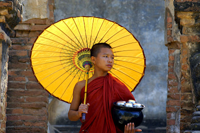
Burma, the "Golden Land" is a mostly Buddhist country. It was conquered by the British in the 19th century and subsequently incorporated into its Indian Empire. It was administered as a province of India until 1937, finally gaining its independence in 1948.
Since 1962, the military has controlled the country, even failing to turn over the governmental power to the opposition party that won a landslide victory in the 1990 general election.
The country is replete with natural resources but growth and progress are stifled by strict government controls and serious financial mismanagement.
Rangoon, the beautiful and mysterious capital city, is the principal port. Tourists are attracted by the city's large number of ancient golden pagodas (monuments to Buddha) that still stand.
Read more about the history of the country here
Facts and Figures
Name Burma (long form) Union of Burma
Note that since 1989 the military authorities in Burma have promoted the name Myanmar as a conventional name for their state. This decision was not (and is not) approved by any sitting legislature in Burma, and is not accepted by the U.S. However, the name Myanmar is now widely accepted by numerous countries and by the United Nations.
Population 42,909,500 (28 out of 192)
Capital City Rangoon (Yangon) (4.2 million)
Currency Kyat (MMK)
Languages Burmese (Myanmar), local dialects
National Day January 4
Religions Buddhist (90%), Christian, Muslim
Geographic Coordinates
Latitude/Longitude (capital city) 16° 47' N, 96° 10' E
Relative Location Burma is in both the eastern and northern hemispheres, and the southern edges of the country are just a few degrees north of the Equator. It's positioned in southeast Asia and bordered by the Bay of Bengal, Andaman Sea, Gulf of Thailand and the countries of Bangladesh, India, China, Laos and Thailand.
Land Statistics
Coastline 1,930 km
Land Areas land 657,740 sq km, water 20,760 sq km, TOTAL 678,500 sq km (39 out of 192)
Landforms The most dominate feature of the country is the Irrawaddy River system, the surrounding valleys and the river's massive delta in the south.
In the far south the Mergui Archipelago contains over 800 islands, most of them completely uninhabited.
The land rises gently into the Shan Plateau in the east, where the average elevation is near 1,000 m. In the far north, the land rises sharply into a southern branch of the Himalayan mountain system.
Highest Point Hkakabo Razi - 5,881 m
Lowest Point Andaman Sea - 0 m
Climate The country has three distinct seasons. (October through February) pleasant conditions where average high temperatures reach 27° c. (March through May) where days are hot and humid, and average high temperatures are near 36° c. Finally, (June through September,) the rainy season, where average highs reach into the high 80s.
From June through early October, monsoon conditions affect the southwest, with extremely heavy rains in the Irrawaddy Delta. From December through April, there's monsoon conditions in the northeast.
Distance between Rangoon, Myanmar (Burma) and Tehran, Iran, as the crow flies:
4878 km
Distance between Rangoon, Myanmar (Burma) and Brisbane, Australia, as the crow flies: 7861 km


هیچ نظری موجود نیست:
ارسال یک نظر