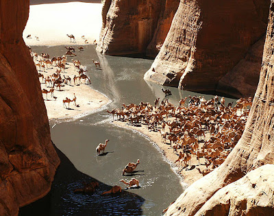


 The ancient land called Chad was inhabited over one million years ago, at a time when much of it was only water. In modern Chad, precious water is often difficult to find, while famine and war seem everywhere.
Over the centuries it served as the stomping-ground of sorts for a litany of cultures and kingdoms, and when the French arrived in 1891, they subsequently controlled it until Chad gained its independence in 1960.
Decades of ethnic warfare followed, as well as invasions from Libya, its most powerful neighbor. A certain level of peace was restored in 1990, but local power struggles continue, and the future of this unstable land is uncertain at best.
Much of the country is positioned within the hot and dry (and mostly unproductive) Sahara Desert, where Chad is covered by sand and barren scrub land. In the far south, and in the southwest, surrounding Lake Chad, conditions improve to support an abundance of wildlife and agricultural ventures.
Chad's economy has recently benefited from a series of major oilfield and pipeline projects, while cattle, cotton and gum arabic have long been the traditional economic mainstays.
Longterm weaknesses include its landlocked position, oppressive poverty, the shrinking of Lake Chad, and the ever increasing expansion of the Sahara Desert.
Facts and Figures
Official Name Republic of Chad
Population 9,944,201 (81 out of 192)
Capital City N'Djamena (680,000)
Largest Cities N'Djamena, Moundou, Sarh
Currency CFA Franc
Latitude/Longitude 12°11' N, 15°05' E
Languages French (official), Arabic (official), and numerous trobal dialects.
National Day 11 August; Independence Day
Religions Muslim, Christian, others
Land
Land Area 1,259,200 sq km (20 out of 192)
Landforms In the northern reaches of the country, the Tibesti Mountains dominate the landscape of the surrounding Sahara Desert.
The Sahel, on the southern edges of the ever-expanding Sahara Desert, is a transition zone between the dry areas of the north and the tropical areas of the south. It receives very little rain, and most of the vegetation is a savanna growth of sparse grasses and shrubs.
The land rise into the Ennedi and Wadai plateaus along the eastern border with Sudan, where elevations reach near 610m.
In the south the forested land is nourished by the Chari and Logone Rivers. During the monsoon rains, Lake Chad often overflows, causing floods in the lowland depression of the south.
Highest Pt. Emi Koussi (3,415 m)
Lowest Pt. Djourab Depression (160 m)
Climate The Sahara Desert regions are hot and dry throughout the year, with little or no rainfall. Temperatures are much cooler along the south-central Sahel. Rainfall there averages near 380mm annually. Drought, however, is commonplace.
In the southern regions, rainfall is much heavier, averaging near 760mm annually. The mean temperature in N'Djamena is 28° C
هیچ نظری موجود نیست:
ارسال یک نظر